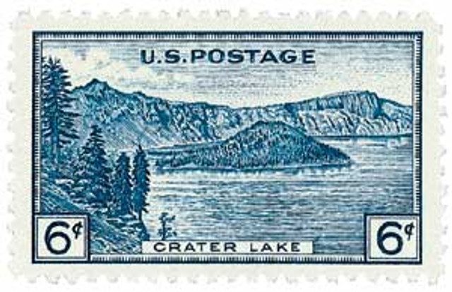
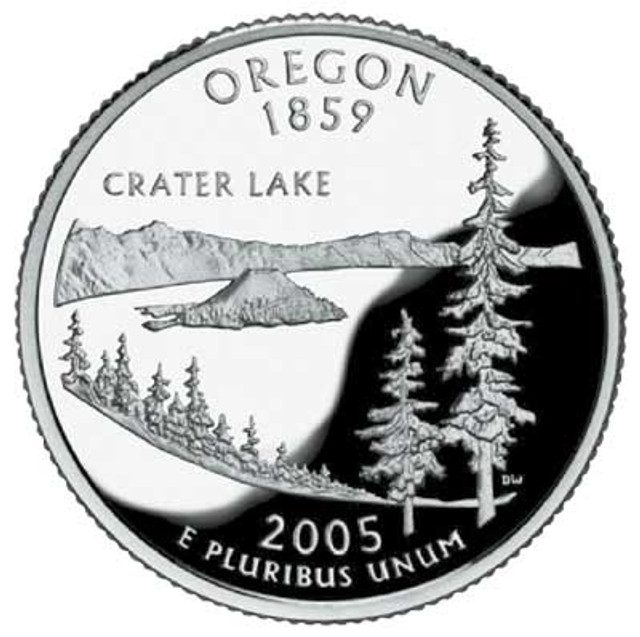
Oregon’s Crater Lake National Park was established on May 22, 1902. It’s America’s fifth-oldest national park, the only national park in Oregon, and is home to the deepest lake in the country – Crater Lake.
Crater Lake was once an enormous volcano called Mount Mazama. It began forming 400,000 years ago, around the same time as the rest of the Cascade volcanic range. Mount Mazama’s frequent eruptions caused it to grow to a height of 11,000 feet, until around 5700 BC.

Geologists estimate it was around this time that a major eruption took place, causing Mount Mazama to implode. The volcano had erupted with a blast 42 times more powerful than the 1980 eruption of Mount St. Helens. The top 5,000 feet of volcano collapsed, and the bottom was sealed by lava flows. A massive caldera (crater) was left behind and filled with about 4.6 trillion gallons rainwater and snowmelt over the course of about 740 years, creating Crater Lake.
Local Native American tribes witnessed Mount Mazama’s collapse and included it in their legends. The Klamath Indians believed that Crater Lake was the home of the spirits and that the lake’s waters had healing qualities.
The lake first became known to non-natives on June 12, 1853. Three gold prospectors found the long, sloping mountain while searching for food. They were surprised by the lake’s vibrant blue color and named it Deep Blue Lake. The site where they first laid eyes on the lake became known as Discovery Point. However, the search for gold held higher priority for the settlers at the time and the discovery was largely forgotten. In time, it came to be called Crater Lake.
William Gladstone Steel is credited as one of the park’s greatest champions. He first came to the lake in 1870 and spent the rest of his life and fortune in efforts to make Crater Lake a national park. He encouraged scientific lake surveys and named many of the surrounding landmarks, including Wizard Island, Llao Rock, and Skell Head.
In 1886, Steel worked with geologist Clarence Dutton in organizing a US Geological Service expedition of the lake. Their team carried a half-ton survey boat up the crater’s steep slopes to get it to the lake. Aboard the boat, they lowered a piece of pipe attached to a piano wire down into the water to measure the lake’s depth at 168 different spots. The deepest point they found, 1,996 feet, came very close to the modern officially recognized depth of 1,949 feet, which was found by sonar. During this expedition, a topographer also made the first professional map of the area. Steel’s expedition and extensive lobbying efforts paid off on May 22, 1902, when President Theodore Roosevelt established Crater Lake as America’s fifth national park.

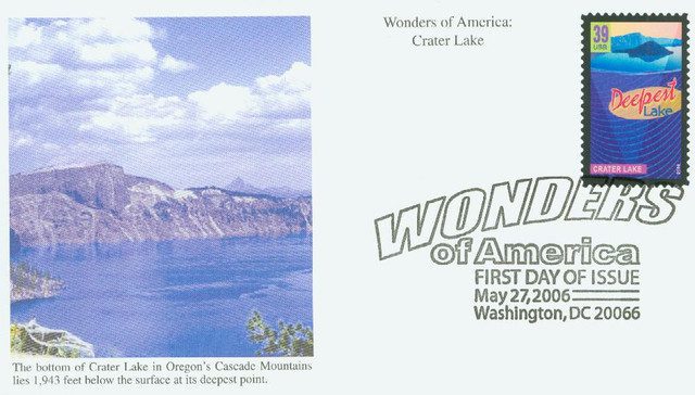
Crater Lake is known for the clarity, purity, and intense blue color of its water. The lake is six miles across at its widest point and covers twenty square miles. Because the lake is so deep, its temperature remains fairly constant throughout the year. It rarely freezes over and makes for striking views in all four seasons. Visitors can see clearly 134 feet into its depths. Today Crater Lake is the second-deepest lake in North America and the ninth-deepest in the world. It is surrounded by miles of unbroken cliffs ranging from over five hundred to nearly two thousand feet in height.
One neat feature of Crater Lake is the “Old Man of the Lake.” The “Old Man” is a 30-foot-tall tree stump that has been bobbing vertically in the lake since it was first noticed in 1896. The “Old Man” wanders around – it has been found floating in all parts of the lake. Geologists have tracked its movements all over the lake, and boaters report its location, for both reasons of safety and curiosity.
Find pictures, history and more at Crater Lake’s official website.
| FREE printable This Day in History album pages Download a PDF of today’s article. Get a binder or other supplies to create your This Day in History album. |
Discover what else happened on This Day in History.
Old Man of the Lake is a pretty cool story.
Crater Lake and the surrounding area is so beautiful in person! The waster is very blue…much like the Mediterranean. ❤️
How amazing we have history going back so long ago. Thank you Mystic Stamp for this amazing background on another great National Park.
Great history of this beautiful lake!
I know I’m a minority of one, but I still believe we’re not as old as was mentioned because of an in depth bible study we had some years ago. How do they know it was 42. Times greater than mt. St. Helens? Who measured it? I do really like the stamp that was issued and most of the article. The older stamps are still more interesting than the more modern ones, at least to me. Thanks again for these articles.
Hi Tom,
Now WE are a minority of 2. Have you ever checked out ICR.org? They have an amazing amount of articles that scientifically back the biblical age of the earth.
I also like the older stamps and the descriptions in Mystic’s Heritage album help bring history alive.
We also celebrate the issuance of the Looney Tunes series.
Funny Jim, and that’s not a knock on the Looney Tunes characters either. My answer to Dave and Tom is stop believing bias opinions and thank GOD that knowing the age of the earth doesn’t matter in heaven my friends.
How do we know how old the earth is? How do we know the blast that created Crater Lake was 42 times greater than the eruption of Mount St. Helens? It’s called science Timm. It’s based on careful observation and the laws of physics, not a 2000-year-old book written before the age of science. Of course you can believe anything you want, but I’ll stick with science.
Oops, my message on May 26 should have been addressed to Tom H. and Dave, not Timm. Dorry about that.